Showing posts with label Coastal Environment. Show all posts

Thursday, February 2, 2017

Dredging and Beneficial Use - Part 2: Shark River Dredging Project

Introduction
For over 30 years, Clean Ocean Action has worked to review, develop, and advocate for community driven dredged material management solutions. By viewing dredged material as a resource, and emphasizing community input and engagement, COA has reviewed and identified potential beneficial use options for dredged material placement in many different contexts and uses. Above all, throughout this process, COA has advocated for environmental protection, and community involvement and support as key tenets of our position. As we say here at Clean Ocean Action, “we know mud”.
This is part two of our series on the beneficial use of dredged material.
SHARK RIVER - Critical Navigation, Innovative Dewatering, and Beneficial Use


The Shark River is a tidal estuary bordered by five towns - Neptune Township, Neptune City, Avon, Belmar and Wall Township. The river is popular for stand up and kayak paddling and bird watching, as well as safe harbor for hundreds of commercial and recreational fishing and pleasure boats. The marinas surrounding the river have also become a focus of redevelopment with bars and restaurants flanking these marina hubs. For over two decades, critical dredging of channels was needed to allow the passage of vessels into and out of the estuary. However, no satisfactory location was available to place the estimated 102,000 cubic yards of dredged material. In fact, the old CDF for Shark River is actually the site of the Seaview at Shark River Island condominium community; a clear example of the lack of open space in the area. Everyone agreed that the river needed to be dredged, but there was no consensus as to where the material could be placed, or even dewatered for transport. An innovative solution was necessary to get this project off the ground.

Enter a dedicated coalition of State, County and local leaders that effectively advocated for the project, including Senator Jen Beck, Committeeman Randy Bishop, County of Monmouth, Board of Chosen Freeholders, New Jersey Department of Transportation (NJ DOT) Office of Maritime Resources, New Jersey Department of Environmental Protection (NJ DEP), and the governing bodies of the participating municipalities including Neptune City, Neptune, Belmar, and Wall. Recognition must also go to the Shark River Cleanup Coalition, who has been advocating for the dredging of the Shark River for many years now. 

NJDOT put a concept and "workable plan" out to bid. Mobile Dredging and Pumping Co., out of Chester, PA. Mobile Dredging was awarded the $7.6 million contract in the summer of 2015, as the responsible low cost bidder for the project, and with coordination from NJDOT and NJDEP, a workable solution was created that used innovative technology to dewater the dredged material slurry on a very small footprint surrounded by homes, businesses, and marinas, before trucking it to the Monmouth County Reclamation Center for use as landfill cover. The project removed approximately 102,000 cubic yards of sediment from the River comprised of sand and silt using hydraulic dredging, and then piped the slurry via a secure welded pipeline to the selected dewatering location.

Caption: far off in the Shark River, the hydraulic dredge removes sediment to improve navigation (photo courtesy of Cindy Zipf).
The dredging had started late last fall and was halted on January 1, 2016, due to state regulations in place to protect spawning and the early life stages of winter flounder and anadromous fish. During this initial phase of the project, “geotubes” were used to dewater the slurry before trucking the material off to be used. Geotubes are large fabric bags that the slurry is pumped into, with pressure forcing the water out of the bag while the sediment remains.
Caption: this image shows the piping system that moves the dredge slurry to the dewatering site, as well as the pipe that takes the water that has been removed out of the sediment and returns it back to the river (photo courtesy of Cindy Zipf).

Caption:  dredge slurry is pumped into the geotube. The fabric is designed to let water escape, leaving behind the sediment for removal and use as cover at a landfill.


When the project was restarted in July, the dewatering process was changed to handle larger amounts of material and get the project done before the dredge window closed.

Caption: a first look at the dewatering site. (video courtesy of Cindy Zipf).


This dewatering process is called “mechanical dewatering” and utilizes transportable and modular centrifuges and belt presses to separate usable sand out of the finer sediment, then mechanically squeeze the water out of the slurry. The process is rather impressive to behold, and when up and running, is able to process a huge amount of material on a very small footprint – perfect for the heavily built up mid-Atlantic coastline.
Let’s walk through the process:


First, a hydraulic dredge removed sediment in a slurry that is piped to the dewatering location. This pipe runs to a large tank that slows down the flow of water and allows larger pieces of debris to settle out.

Caption: Rick, from Clean Ocean Action, talks to the contractor supervisor in front of one of the large tanks where the dredge slurry is first pumped to (photo courtesy of Cindy Zipf).
The slurry is then pumped into several centrifuge and screen type machines, that are able to sort out debris and coarse sand sediments from the muds and silts. These machines are also able to remove large amounts of debris and trash from the sediment as well. The idea is that the larger pieces of debris and sand can actually harm the belt presses which squeeze the water out, so removing them on the front end of this process saves those machines, and also allows for use of sand! This project produced about 500 cubic yards of sand that was trucked and placed on the Township of Neptune’s beaches.

Caption: Bill from NJDOT shows us the centrifuge systems which remove the larger sediments and debris on the front end of this process (photo courtesy of Cindy Zipf).


Caption: The centrifuges are able to remove debris and shell fragments which are removed from river and properly disposed of (photos courtesy of Cindy Zipf).


 Caption: Zach from COA inspects the sand removed off of the front end this process - over 90% sand = perfect for beach placement (photo courtesy of Cindy Zipf).

The slurry then travels to belt presses which wring the water out of the slurry and extrude a dredge material “brownie” (photo courtesy of Cindy Zipf)..
Caption:  the mechanical dewatering process in a series of videos (courtesy of Cindy Zipf).

1. After having larger sediment and debris removed, a polymer is added to the slurry and then spread out onto the fabric conveyor belts

2. The conveyor belts transport the slurry through a series of belt presses, which mechanically squeeze the water out of the material. This process occurs several times. Water from this process is treated and sent back into the Shark River.


3. The dredge material, now dewatered, is extruded out of the belt presses.


Caption: the result of this dewatering process is a sediment "brownie" that has been wrung dry, and easily transportable (photo courtesy of Cindy Zipf).


This material is then scooped up and put in a holding area, where dump trucks then take it to the Monmouth County Reclamation center, where it will be mixed with sand and used as landfill cover (photo courtesy of Cindy Zipf).
The Shark River project is a great example of coupling an innovative dewatering process with beneficial use of the material, in order to meet the constrains of the project. The mechanical dewatering process took up about an acre of area, was self contained and rather unobtrusive to the surrounding area, and allowed sand to be harvested off the front end for beach placement, and sediment off the back end for landfill cover (photo courtesy of Cindy Zipf).

A final note: the footprint of one acre for dewatering was barely enough room to get this job done. A larger footprint for dewatering would have made the project less expensive and faster to complete. Furthermore, Monmouth County Landfill accepting the material for free was a key in making this project feasible. This all goes to show that finding large scale, affordable, beneficial use opportunities is really challenging - and cooperation and coordination between all entities is absolutely essential to the success of these types of projects.


Thursday, January 26, 2017

Dredging and Beneficial Use - Part 1: Manasquan Inlet


1

Introduction
For over 30 years, Clean Ocean Action has worked to review, develop, and advocate for community driven dredged material management solutions. By viewing dredged material as a resource, and emphasizing community input and engagement, COA has reviewed and identified potential beneficial use options for dredged material placement in many different contexts and uses. Above all, throughout this process, COA has advocated for environmental protection, and community involvement and support as key tenets of our position. As we say here at Clean Ocean Action, “we know mud”.

In the last several years, we have been monitoring what many call a “dredge crisis” – thousands of cubic yards of dredge material are waiting to be dredged out of critical navigational channels, however, without proper planning and community engagement, and the use of innovative technologies, the disposal options for all of this dredged material is limited. Without a plan to deal with all of this dredged material, these projects are put on hold; in some cases, for decades.

Traditionally, Confined Disposal Facilities (CDFs) were used as both temporary and final disposal locations for this material. CDFs are engineered structures designed to provide storage for the soupy mix of suspended solids that are dredged out of channels and pumped into them. These structures traditionally appear as the familiar hills and berms that you may see rising out of the wetlands in many locations. In general, these CDFs can fill up rather quickly, are expensive to continually maintain, and many of these CDFs have fallen into disrepair over the years, further limiting disposal options.

Today, there are many solutions for clean dredge material placement including beneficial use options such as using the sediment in construction fill or cover for landfills (for contaminated dredge material the options are rightfully more limited). However, for these uses, the soupy, watery dredged material must be “dewatered” so that it can be transportable and useful. Most dewatering methods involve the use of a CDF, the construction of temporary CDFs on land to dewater the material before trucking it off, or even the use of other technologies to dewater the material in short amounts of time and on increasingly smaller footprints.

Furthermore, there are methods that can beneficially use dredged material without dewatering. Methods have been continually perfected to perform habitat restoration projects through the creation of “living shorelines” and the “thin layer placement” of material on a drowning marsh, and for the right types of material, can be pumped onto bayside and ocean beaches to fortify erosion areas and safeguard communities from storms.

COA recently visited two separate locations where innovative dewatering and placement methods have resulted in projects that provide benefits to boaters on the water, communities on land, and beneficial material for a multitude of uses.

Manasquan Inlet – Channel Dredging, Beach Placement and Erosion Control


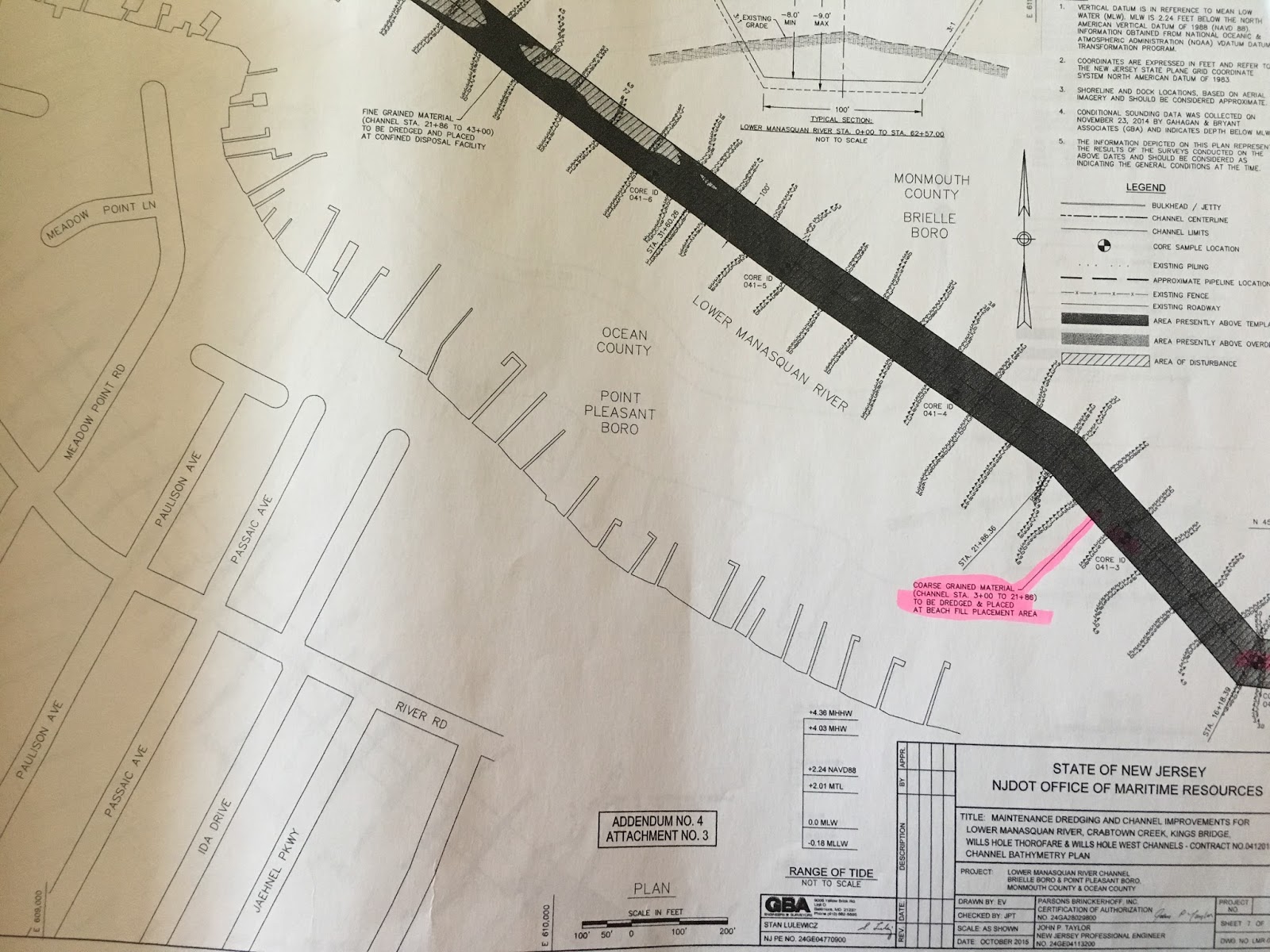
The Manasquan Inlet dredging project was permitted and put out to bid in the fall of 2015. The project permitted the dredging of the Lower Manasquan River Channel, Crabtown Creek Channel, Kings Bridge Channel, Wills Hole Thorofare, and Wills Hole West Channel. In total, over 100,000 cubic yards of material were permitted to be removed from these navigation channels.

In New Jersey, only material that is 75% sand or greater is allowed to be placed on beaches. The State however goes a step beyond this and only places material that is 90% or greater sand on bathing beaches (ie lifeguarded beaches), and 75% or greater sand material may be placed on non-bathing beaches (for example a bayside beach without a lifeguard). This is important for two reasons: 1) grain size directly relates to sand quality, which is an important consideration for those residents and visitors who come to the Jersey Shore to recreate on our world renowned sand beaches. 2) 90% sand or greater is given a “pass” from further chemical analysis because NJDEP have determined that once material reaches 90% sand in grain size, that material no longer is a risk for contamination. Therefore once this material is determined to be 90% or greater sand, no further chemical analysis is required. 

A sediment grain size analysis evaluating core samples taken at lengths along the channels was conducted by NJ Department of Transportation and reviewed by NJDEP and COA.

Roughly 57,000 cubic yards of sediment from the channels was found to be less than 90% sand - fine grained mud and silt. Gull Island is a CDF that sits smack in the middle of the river, and was designated and permitted as the receptacle for the majority of the fine grained material.

Caption: Gull Island CDF elevation map - a "bowl" for the fine grained dredge slurry (courtesy of Jersey Shore Drone)


However, approximately, 47,500 cubic yards of dredged material in specific locations of the Lower Manasquan Channel and Wills Hole Thorofare were found to contain 90% sand or greater, and  therefore suitable for placement on the beach between Manasquan Jetty and Brielle Road. This area of the beach was replenished by a larger federally overseen project in the past, however due to ocean currents and storms, is prone to erosion. Placing appropriate sand from the dredging project directly onto the beach helps to supplement and fortify the beach at this erosion prone area, and saves time, money and space for this dredging project, and future dredge and beach nourishment projects.

Caption: dredging Wills Hole Thoroughfare next to Gull Island CDF (photos courtesy of Jersey Shore Drone):

Sand that has been in the bays for several months, and even years, typically appear dark compared to sand that is found on the beach due to the presence of organic content from decaying vegetation and animals and the settling of these particles to the bay floor.  As this displaced sand dries and is exposed to sunlight and wave action, the dark organic material will weather and bleach out, and its color will change to resemble the color of sand that typically is found on New Jersey beaches.  This is similar to what we observe in typical beach replenishment projects in New Jersey: the sand that is pumped onto area beaches from the ocean and inlets is also dark when first placed on the beach, and then it lightens as it dries and is exposed to sunlight. The hydraulic dredging process may also pick up debris and trash that was buried in or sat on top of the sediment. 
Caption: 90% or greater sand with darker organic content that was pumped from Manasquan Channel and Wills Hole Thoroughfare directly onto the beach. Sunlight, rain, and wind action will eventually weather away  and wash out the darker organic matter leaving the lighter colored sand behind (photos courtesy of Jersey Shore Drone).

The site of a pipe on the beach releasing a dark colored slurry is an uncommon one for many people. However, when properly designed and vetted, these projects represent an innovative and beneficial use of material to protect properties and communities, save time and money, and perhaps contribute to less frequent large scale, federal beach nourishment projects that cost millions of dollars.

Caption: dredge slurry containing 90% or greater sand is pumped onto the Manasquan Beach, providing erosion control and protection from storms (photo courtesy Zach Lees):


It may not always be pretty -while there was some debris and trash picked up by the dredging process, the Borough of Manasquan worked in closely with NJDOT to utilize their beach rakes to remove this material, and with further coordination from the dredging contractor, ensured that larger items were captured prior to placement on the beach.


Caption: Borough of Manasquan raking the newly placed sand for any debris and shells that made it through the screens (photo courtesy Zach Lees).


Caption: Video taken by Jersey Shore Drones shows the Borough of Manasquan raking out any debris and spreading the newly placed sand out to weather out the darker organic material.


COA reviewed the permits and sediment analysis authorizing this project, and visited the beach placement site with NJ Department of Transportation (state agency in charge of state navigational channel dredging) and a representative from the Borough of Manasquan. The sediment analysis showed that each core sample was 90% or more sand, and that the dredged areas that were designated for beach placement were chosen with caution in mind, and a clear understanding of the value of New Jersey’s beautiful beaches. 


While the initial placement of this material may look a bit different than the surrounding sand, this is a temporary issue that will fade away with time, and this type of project is a model for the type of innovative beneficial use projects that can be designed to help move forward necessary navigational channel dredging, while also fortifying NJ’s beaches from storms and sea level rise.


NOTE: most all of the pictures we used of the Manasquan Channel dredging project, including the one below, are courtesy of Jersey Shore Drone, who has an incredible website that we highly recommend: http://www.jerseyshoredrone.com/2016/11/njdot-manasquan-river-dredging-11272016.html

Caption: a final shot by Jersey Shore Drone of the beach placement site. Note the "bump out" already provided by the project, in an area that was previously eroded.


[1] Credit to Jersey Shore Drone, who has done some incredible work visualizing and documenting many of these locations on the Jersey Shore. http://www.jerseyshoredrone.com/2016/04/nj-dot-manasquan-river-dredging-project.html

Wednesday, January 13, 2016

What’s Up with Water in New Jersey?

                People have a complex relationship with water. We swim in it and recreate on it, fish from it and withdraw huge amounts from rivers and coastal waters for industrial use and drinking water. At the same time, we discharge millions of gallons of wastewater right back into those waterways and waterbodies. Continued population and development pressures, coupled with the present and future impacts of climate change, threaten the quality and abundance of this most essential resource. Unfortunately, New Jersey has done a poor job in planning and regulating these issues. As a result, NJ is losing hard won progress and is actively backsliding on water quality protections.

This past year was one of the driest on record for New Jersey, with nearly one-fifth (located mostly in Central and Northeastern) of the state classified in a moderate drought and nearly 90 percent of the state listed as abnormally dry.[1] These low water levels stress ecosystems and drinking water supplies. This ‘trend’ extends back several years, and, with the ever more apparent effects of a warming climate, foreshadows a new normal. As our own NJDEP has stated, “[d]espite a trend toward more precipitation, the Northeast is seeing longer periods without rainfall and longer growing seasons. The result is a drier growing season, especially during the summer months, when temperatures and evapotranspiration are highest. This summer’s drying trend is exacerbated by reduced recharge from spring snowmelt. New Jersey has experienced one severe water-supply drought (2001-2002) and three minor ones (2005, 2006 and 2010) in the last decade.”[2] Even now, the NJDEP Drought Information website shows “a Drought Watch remains in place in the Northeast, Central, and Coastal North Water Supply Regions. . .  Substantial rainfall will be needed over the coming months to restore water supply reserves in preparation for the high-demand season that beings in May.”[3] Yet, NJDEP has neglected the critical tasks of inventorying and managing this precious resource, as the current Water Supply Master Plan (WSMP) is 20 years old and 15 years overdue, despite widespread protest and opposition from elected officials and environmental organizations.[4]

The WSMP inventories the amounts of surface and underground drinking water in the State and compares it to the amounts withdrawn for residents, business, power production, and farming in order to achieve a balance between development, water withdrawals, and environmental health. Overdevelopment and an expanding population creates more impervious surface, which inhibits rainwater from percolating into the ground to recharge aquifers and increases water withdrawals, putting our groundwater resources at risk.[5] Without a master plan in place, New Jersey could face severe water shortages into the future.

Furthermore, building in low lying areas, much of which acts as a buffer to absorb run off and storm surge, should be discouraged due to climate change impacts of sea level rise, extended dry periods (which dry out soil and decrease its ability to absorb rain) followed by heavy rain events, and increased frequency of storm events.[6] Yet, in the past year, New Jersey has amended two essential sets of regulations protecting critical coastal and riparian areas that buffer and protect communities from flood waters and absorb nutrients and pollutants before they reach waterbodies. NJDEP consolidated a patchwork of coastal development regulations and ‘streamlined’ it into what is known as the Coastal Zone Management Rules (CZMR). These changes enable even more development in vulnerable coastal areas through a myriad of measures, including easing the process for getting waterfront building permits and enabling larger upland development in the coastal zone.[7] The Flood Hazard Area Control Act (FHACA) establishes buffer distances for streams and rivers, and addresses how we develop in these riparian and coastal areas. These regulations have also been ‘streamlined, which in effect, removes protective waterway designations, and allows increased and unmonitored development in essential riparian, coastal, and wetland habitat.[8]

NJDEP is also in the process of ‘updating’ its Water Quality Management Planning regulations (WQMP).[9] These rules are required for New Jersey to meet its obligations under the Federal Clean Water Act, and determine, among other things, the cumulative water resource impacts of future development, how to manage and restore existing water quality impairments, and how NJ expects to maintain existing water quality.  However, simply put, NJDEP’s proposed updates to the WQMP are damaging to water quality protection, and allow for increased development and associated water quality impacts from sewers, wastewater treatment plants, and runoff in coastal areas.

Overall, New Jersey has a holistic and systemic problem. Development in coastal and riparian areas is continuing unabated, even as the public safety, economic, ecosystem, and water quality impacts of this type of development become clear (FHACA, and CZMR). New Jersey continues to use vast amounts of surface and ground water for drinking, industry, and agriculture, even while drought continues to impact our region (WSMP). New Jersey is also failing to safeguard the water quality gains made in the past, and is failing to properly plan for the future impacts of development on these gains (WQMP).

Stream and groundwater withdrawals, wastewater and industrial discharges, and development in coastal and riparian habitat are continuing unrestricted. Poor integration among these regulations and a lack of planning for future population increases and development will stress ecosystems, put human health at risk, and is a dangerous and unsustainable path into an uncertain climate future.

New Jersey’s water protection laws and planning are heading in the wrong direction. Clean water for drinking, swimming, fishing, and agriculture is invaluable.  Clean Ocean Action will continue to fight for clean water, and encourages the public to engage with us to protect this most basic and essential resource. Follow our social media for important updates and action alerts, call or email your elected officials and speak up for water quality and habitat protections, and align your lifestyle and consumption patterns with low impact and environmentally friendly values.


[2] Climate Change in New Jersey: Temperature, Precipitation, Extreme Events and Sea Level, NJDEP, available at http://www.nj.gov/dep/dsr/trends/pdfs/climate-change.pdf
[5] According to preliminary research by the Association of New Jersey Environmental Commissions (ANJEC), more water is being taken out than is being replenished in one of our major aquifers, the Kirkwood-Cohansey in South Jersey. That aquifer, which runs beneath southern Monmouth County and all of Ocean County, supplies drinking water to approximately 3 million of New Jersey’s 9 million residents. 

Thursday, August 21, 2014

Turtle Treasures

Written by: Scott Thompson


Last week (week of July 14th) during a “liquid lunch” surf session in Sea Bright, I observed a mid - sized (12 to 14” shell size) sea turtle cruising within the lineup hopefully enjoying his or her “lunch “ as well. Needless to say I was thrilled with the visual and saw the turtle multiple times in the area during the hour or so in the water enjoying the water more than ever.

This is the first time in my 49 years of surfing that I have ever seen a turtle this close to the shore here in the Atlantic. Is it a good thing? I don’t know, maybe they should be further offshore, however I can indeed attest to the fact that it looked healthy and happy swimming vigorously in and around the breaking surf.

Will there be more? Let’s hope so. However, with all the pressure from outside interests to “explore” the oceans for “data” how can that disruption be positive for the turtles and their environment. Now more than ever we need the CLEAN OCEAN ZONE. Why? Be COZ ! The turtles and all marine life need us to advocate for them so the “data” gathers cannot drive them from their habitat for the good of a few pennies on someone’s spread sheet and account balance.

Call, email and connect with all your legislators and tell them the President and his Cabinet do NOT represent the people. They represent special interests that will sell out our natural ocean resources for a dollar. Is it really worth it in the end?

Thursday, June 20, 2013

Groups File Notice of Intent to Sue EPA for Failure to Protect Beachgoers from Water Pollution

Press contact: Sean Dixon, Clean Ocean Action 732-872-0111, Policy@CleanOceanAction.org
                        Tina Posterli, Riverkeeper 516-526-9371, tposterli@riverkeeper.org
                        Matt King, Heal the Bay, 310-451-1500 ext. 137, mking@healthebay.org
                        Blair Fitzgibbon, Waterkeeper Alliance, 202-503-6141, Blair@fitzgibbonmedia.com


EPA’s new water quality criteria fail to protect human health as required by the BEACH Act.
NEW YORK, N.Y. (June 20, 2013) – The Environmental Protection Agency has failed to meet its legal responsibility to adopt water quality criteria that address the health threat posed by pollution at U.S. beaches, according to a notice of intent to sue filed by a coalition of local and national organizations concerned about beach water quality. The groups are Clean Ocean Action, Hackensack Riverkeeper, Heal the Bay, Natural Resources Defense Council, NY/NJ Baykeeper, Riverkeeper and Waterkeeper Alliance.

“Too many of America’s beaches are sick – and they’re passing on their illnesses to families across the country,” said Steve Fleischli, Water Program Director at the Natural Resources Defense Council. “But EPA is not doing its job to help make sure we are safe when our families head to the beach.”

More than 180 million people visit coastal and Great Lakes beaches every year, and swimming and surfing are favorite pastimes in the United States. But beach closings due to hazardous contamination remain near all-time highs. In 2011, there were over 23,000 beach closing and health advisory days across the country. More than two-thirds of the closing and advisory days were prompted by dangerously high bacteria levels, indicating the presence of human or animal waste. The underlying culprits are generally improperly treated sewage, animal manure and contaminated stormwater runoff, which have a highly deleterious effect on water quality.

This pollution poses a significant threat to public health. Pathogens in contaminated waters can cause a wide range of diseases – including gastroenteritis, dysentery, hepatitis, and respiratory illness. However, despite these risks, EPA’s latest actions fail to protect people who choose to recreate in coastal waters. EPA has estimated that up to 3.5 million people become ill annually from contact with either overflow of overburdened sewage treatment plants during storm events, leakage from faulty infrastructure, or inappropriate sewage treatment.

“A day at the beach should never make someone sick,” said Kirsten James, Science and Policy Director for Water Quality at Heal the Bay. “EPA missed a major opportunity and a legal mandate to upgrade its recreational water quality criteria to better protect the public from the dangers of polluted water at U.S. beaches. This must be corrected.”

In 2000, Congress enacted the Beaches Environmental Assessment and Coastal Health Act (BEACH Act), requiring EPA to modernize criteria for water quality that would protect beach users from illnesses caused by pathogens, such as viruses and bacteria. EPA updated these criteria in 2012. However, EPA’s 2012 criteria are inadequate and fail to protect public health in several ways:

  • EPA’s criteria fail to protect against single day exposures to pathogens. 
  • EPA now allows water quality samples to exceed contamination levels EPA has determined are unsafe up to 10% of the time without triggering a violation. This approach could mask a serious pollution problem and expose families to an unnecessary risk of illness from recreating in local waterways.
  • EPA’s new criteria also fail to address the risk of non-gastrointestinal illnesses – such as rash and ear infections – that result from recreating in contaminated waters. The agency concluded that addressing stomach illnesses would adequately protect the public from other types of ailments.
  • EPA’s criteria permit a level of risk that would result in 36 of every 1000 beachgoers becoming ill with vomiting, nausea, or stomachaches. This level of risk is unacceptably high.

“Swimmers deserve to know that their favorite beach is clean on the day they're using it. It doesn't matter to them one bit what the average water quality was a month ago,” said Captain Bill Sheehan, the Hackensack Riverkeeper. “New Jersey discharges 23 billion gallons of sewage per year from permitted sewer overflows. Sometimes our waters are clean, sometimes they are dangerous; we are not safe unless we know which is true on a daily basis.”

“The New York-New Jersey Harbor has seen both increasing recreational use and increasing impacts from disease causing pollution,” said Deborah A. Mans, the NY/NJ Baykeeper. “We need EPA to let people know when the water is safe and to punish polluters when it is not. A monthly standard just does not protect public health.”

“EPA’s criteria is doubly flawed because it not only assumes that is acceptable for 36 of every 1000 people to contract gastro-intestinal illness by recreating in contaminated water, an unacceptably high number; it also ignores the proven risk of other health impacts, from rashes to eye and ear infections that routinely plague swimmers in our waterways,” said Phillip Musegaas, Hudson River Program Director for Riverkeeper. “People recreating in the Hudson River must be protected with strict standards, utilizing the best science to truly protect public health rather than the EPA’s status quo.”

“Science-based criteria for pathogens in recreational waters are the cornerstone of the Clean Water Act’s protections against widespread pollution by animal manure and human sewage and are essential to protecting people that swim and fish in our nation’s waterways from pathogenic illness,” said Kelly Foster, Senior Attorney for Waterkeeper Alliance. “EPA has adopted criteria that do not protect the public from disease when swimming and fishing, make it more difficult to reduce or eliminate pathogens from our recreational waters, and do not adequately inform the public about the risk they face when deciding to go to the beach. Without adequate recreational criteria, the Clean Water Act simply cannot function to adequately protect us from disease when swimming at our nation’s beaches and recreational waters.”

“The beaches, boardwalks, and bays of the nation drive billion-dollar coastal economies,” said Cindy Zipf, Executive Director of Clean Ocean Action, “having clean, safe beaches where parents, children, tourists, locals, surfers, and fishermen can enjoy a day at the beach without a day at the doctor’s is the keystone condition for these clean coastal economies. The EPA has failed in its duty to protect beachgoers using the best science, and has failed to develop a system that warns the public of health risks before they happen – not several days or weeks later.”

###

Clean Ocean Action is a coalition-based non-profit organization working to improve and protect the water quality of the marine waters off the New Jersey and New York coasts. Follow us @CleanOcean or online through www.CleanOceanAction.org

Hackensack Riverkeeper is a non-profit corporation organized to provide representation for the living resources of the Hackensack River. Hackensack Riverkeeper runs boat tours and operates a paddling center on the Hackensack River in the Meadowlands, and has its offices in Hackensack New Jersey. Captain Bill Sheehan founded Hackensack Riverkeeper fifteen years ago. www.hackensackriverkeeper.org

Heal the Bay is a non-profit organization dedicated to preserving Santa Monica Bay and all southern California coastal waters and watersheds. Progress toward the mission is achieved by effectively combining the use of science, advocacy, community outreach, and public education to create positive environmental change. For over two decades, Heal the Bay has been effective in cleaning up polluted waterbodies, including freshwater and coastal waters, to better protect the health of the public and aquatic life throughout the Los Angeles region. www.healthebay.org

The Natural Resources Defense Council (NRDC) is an international nonprofit environmental organization with more than 1.4 million members and online activists. Since 1970, our lawyers, scientists, and other environmental specialists have worked to protect the world's natural resources, public health, and the environment. NRDC has offices in New York City, Washington, D.C., Los Angeles, San Francisco, Chicago, Livingston, Montana, and Beijing. Visit us at www.nrdc.org and follow us on Twitter @NRDC.

NY/NJ Baykeeper is a non-profit corporation working to protect, preserve, and restore the ecological integrity and productivity of the New York/ New Jersey Bay. Baykeeper conducts restoration programs, especially oyster restoration, in both New York and New Jersey waters, works to acquire land for preservation and advocates for clean water throughout its coverage area – extending from Sandy Hook, New Jersey through Jamaica Bay Queens. Debbie Mans is the NY/NJ Baykeeper. http://nynjbaykeeper.org/

Riverkeeper is a membership-based, non-profit group dedicated to defending the Hudson River and its tributaries and protecting the drinking water supply of New York City and Hudson Valley residents. Through enforcement, grassroots advocacy and policy initiatives Riverkeeper has helped to establish globally recognized standards for waterway and watershed protection, and serves as the model for the growing Waterkeeper movement that includes nearly 200 Keeper programs across the country and around the globe. For more information please go to www.riverkeeper.org

Waterkeeper Alliance is an international alliance of water advocates working to patrol and protect rivers, streams, and coastlines around the world. Waterkeeper Alliance represents the interests of over 200 member watershed organizations providing a way for communities to stand up for their right to clean water. Visit us at http://www.waterkeeper.org and follow us on Twitter @Waterkeeper.