Showing posts with label New Jersey. Show all posts

Thursday, February 2, 2017

Dredging and Beneficial Use - Part 2: Shark River Dredging Project

Introduction
For over 30 years, Clean Ocean Action has worked to review, develop, and advocate for community driven dredged material management solutions. By viewing dredged material as a resource, and emphasizing community input and engagement, COA has reviewed and identified potential beneficial use options for dredged material placement in many different contexts and uses. Above all, throughout this process, COA has advocated for environmental protection, and community involvement and support as key tenets of our position. As we say here at Clean Ocean Action, “we know mud”.
This is part two of our series on the beneficial use of dredged material.
SHARK RIVER - Critical Navigation, Innovative Dewatering, and Beneficial Use


The Shark River is a tidal estuary bordered by five towns - Neptune Township, Neptune City, Avon, Belmar and Wall Township. The river is popular for stand up and kayak paddling and bird watching, as well as safe harbor for hundreds of commercial and recreational fishing and pleasure boats. The marinas surrounding the river have also become a focus of redevelopment with bars and restaurants flanking these marina hubs. For over two decades, critical dredging of channels was needed to allow the passage of vessels into and out of the estuary. However, no satisfactory location was available to place the estimated 102,000 cubic yards of dredged material. In fact, the old CDF for Shark River is actually the site of the Seaview at Shark River Island condominium community; a clear example of the lack of open space in the area. Everyone agreed that the river needed to be dredged, but there was no consensus as to where the material could be placed, or even dewatered for transport. An innovative solution was necessary to get this project off the ground.

Enter a dedicated coalition of State, County and local leaders that effectively advocated for the project, including Senator Jen Beck, Committeeman Randy Bishop, County of Monmouth, Board of Chosen Freeholders, New Jersey Department of Transportation (NJ DOT) Office of Maritime Resources, New Jersey Department of Environmental Protection (NJ DEP), and the governing bodies of the participating municipalities including Neptune City, Neptune, Belmar, and Wall. Recognition must also go to the Shark River Cleanup Coalition, who has been advocating for the dredging of the Shark River for many years now. 

NJDOT put a concept and "workable plan" out to bid. Mobile Dredging and Pumping Co., out of Chester, PA. Mobile Dredging was awarded the $7.6 million contract in the summer of 2015, as the responsible low cost bidder for the project, and with coordination from NJDOT and NJDEP, a workable solution was created that used innovative technology to dewater the dredged material slurry on a very small footprint surrounded by homes, businesses, and marinas, before trucking it to the Monmouth County Reclamation Center for use as landfill cover. The project removed approximately 102,000 cubic yards of sediment from the River comprised of sand and silt using hydraulic dredging, and then piped the slurry via a secure welded pipeline to the selected dewatering location.

Caption: far off in the Shark River, the hydraulic dredge removes sediment to improve navigation (photo courtesy of Cindy Zipf).
The dredging had started late last fall and was halted on January 1, 2016, due to state regulations in place to protect spawning and the early life stages of winter flounder and anadromous fish. During this initial phase of the project, “geotubes” were used to dewater the slurry before trucking the material off to be used. Geotubes are large fabric bags that the slurry is pumped into, with pressure forcing the water out of the bag while the sediment remains.
Caption: this image shows the piping system that moves the dredge slurry to the dewatering site, as well as the pipe that takes the water that has been removed out of the sediment and returns it back to the river (photo courtesy of Cindy Zipf).

Caption:  dredge slurry is pumped into the geotube. The fabric is designed to let water escape, leaving behind the sediment for removal and use as cover at a landfill.


When the project was restarted in July, the dewatering process was changed to handle larger amounts of material and get the project done before the dredge window closed.

Caption: a first look at the dewatering site. (video courtesy of Cindy Zipf).


This dewatering process is called “mechanical dewatering” and utilizes transportable and modular centrifuges and belt presses to separate usable sand out of the finer sediment, then mechanically squeeze the water out of the slurry. The process is rather impressive to behold, and when up and running, is able to process a huge amount of material on a very small footprint – perfect for the heavily built up mid-Atlantic coastline.
Let’s walk through the process:


First, a hydraulic dredge removed sediment in a slurry that is piped to the dewatering location. This pipe runs to a large tank that slows down the flow of water and allows larger pieces of debris to settle out.

Caption: Rick, from Clean Ocean Action, talks to the contractor supervisor in front of one of the large tanks where the dredge slurry is first pumped to (photo courtesy of Cindy Zipf).
The slurry is then pumped into several centrifuge and screen type machines, that are able to sort out debris and coarse sand sediments from the muds and silts. These machines are also able to remove large amounts of debris and trash from the sediment as well. The idea is that the larger pieces of debris and sand can actually harm the belt presses which squeeze the water out, so removing them on the front end of this process saves those machines, and also allows for use of sand! This project produced about 500 cubic yards of sand that was trucked and placed on the Township of Neptune’s beaches.

Caption: Bill from NJDOT shows us the centrifuge systems which remove the larger sediments and debris on the front end of this process (photo courtesy of Cindy Zipf).


Caption: The centrifuges are able to remove debris and shell fragments which are removed from river and properly disposed of (photos courtesy of Cindy Zipf).


 Caption: Zach from COA inspects the sand removed off of the front end this process - over 90% sand = perfect for beach placement (photo courtesy of Cindy Zipf).

The slurry then travels to belt presses which wring the water out of the slurry and extrude a dredge material “brownie” (photo courtesy of Cindy Zipf)..
Caption:  the mechanical dewatering process in a series of videos (courtesy of Cindy Zipf).

1. After having larger sediment and debris removed, a polymer is added to the slurry and then spread out onto the fabric conveyor belts

2. The conveyor belts transport the slurry through a series of belt presses, which mechanically squeeze the water out of the material. This process occurs several times. Water from this process is treated and sent back into the Shark River.


3. The dredge material, now dewatered, is extruded out of the belt presses.


Caption: the result of this dewatering process is a sediment "brownie" that has been wrung dry, and easily transportable (photo courtesy of Cindy Zipf).


This material is then scooped up and put in a holding area, where dump trucks then take it to the Monmouth County Reclamation center, where it will be mixed with sand and used as landfill cover (photo courtesy of Cindy Zipf).
The Shark River project is a great example of coupling an innovative dewatering process with beneficial use of the material, in order to meet the constrains of the project. The mechanical dewatering process took up about an acre of area, was self contained and rather unobtrusive to the surrounding area, and allowed sand to be harvested off the front end for beach placement, and sediment off the back end for landfill cover (photo courtesy of Cindy Zipf).

A final note: the footprint of one acre for dewatering was barely enough room to get this job done. A larger footprint for dewatering would have made the project less expensive and faster to complete. Furthermore, Monmouth County Landfill accepting the material for free was a key in making this project feasible. This all goes to show that finding large scale, affordable, beneficial use opportunities is really challenging - and cooperation and coordination between all entities is absolutely essential to the success of these types of projects.


Thursday, January 26, 2017

Dredging and Beneficial Use - Part 1: Manasquan Inlet


1

Introduction
For over 30 years, Clean Ocean Action has worked to review, develop, and advocate for community driven dredged material management solutions. By viewing dredged material as a resource, and emphasizing community input and engagement, COA has reviewed and identified potential beneficial use options for dredged material placement in many different contexts and uses. Above all, throughout this process, COA has advocated for environmental protection, and community involvement and support as key tenets of our position. As we say here at Clean Ocean Action, “we know mud”.

In the last several years, we have been monitoring what many call a “dredge crisis” – thousands of cubic yards of dredge material are waiting to be dredged out of critical navigational channels, however, without proper planning and community engagement, and the use of innovative technologies, the disposal options for all of this dredged material is limited. Without a plan to deal with all of this dredged material, these projects are put on hold; in some cases, for decades.

Traditionally, Confined Disposal Facilities (CDFs) were used as both temporary and final disposal locations for this material. CDFs are engineered structures designed to provide storage for the soupy mix of suspended solids that are dredged out of channels and pumped into them. These structures traditionally appear as the familiar hills and berms that you may see rising out of the wetlands in many locations. In general, these CDFs can fill up rather quickly, are expensive to continually maintain, and many of these CDFs have fallen into disrepair over the years, further limiting disposal options.

Today, there are many solutions for clean dredge material placement including beneficial use options such as using the sediment in construction fill or cover for landfills (for contaminated dredge material the options are rightfully more limited). However, for these uses, the soupy, watery dredged material must be “dewatered” so that it can be transportable and useful. Most dewatering methods involve the use of a CDF, the construction of temporary CDFs on land to dewater the material before trucking it off, or even the use of other technologies to dewater the material in short amounts of time and on increasingly smaller footprints.

Furthermore, there are methods that can beneficially use dredged material without dewatering. Methods have been continually perfected to perform habitat restoration projects through the creation of “living shorelines” and the “thin layer placement” of material on a drowning marsh, and for the right types of material, can be pumped onto bayside and ocean beaches to fortify erosion areas and safeguard communities from storms.

COA recently visited two separate locations where innovative dewatering and placement methods have resulted in projects that provide benefits to boaters on the water, communities on land, and beneficial material for a multitude of uses.

Manasquan Inlet – Channel Dredging, Beach Placement and Erosion Control


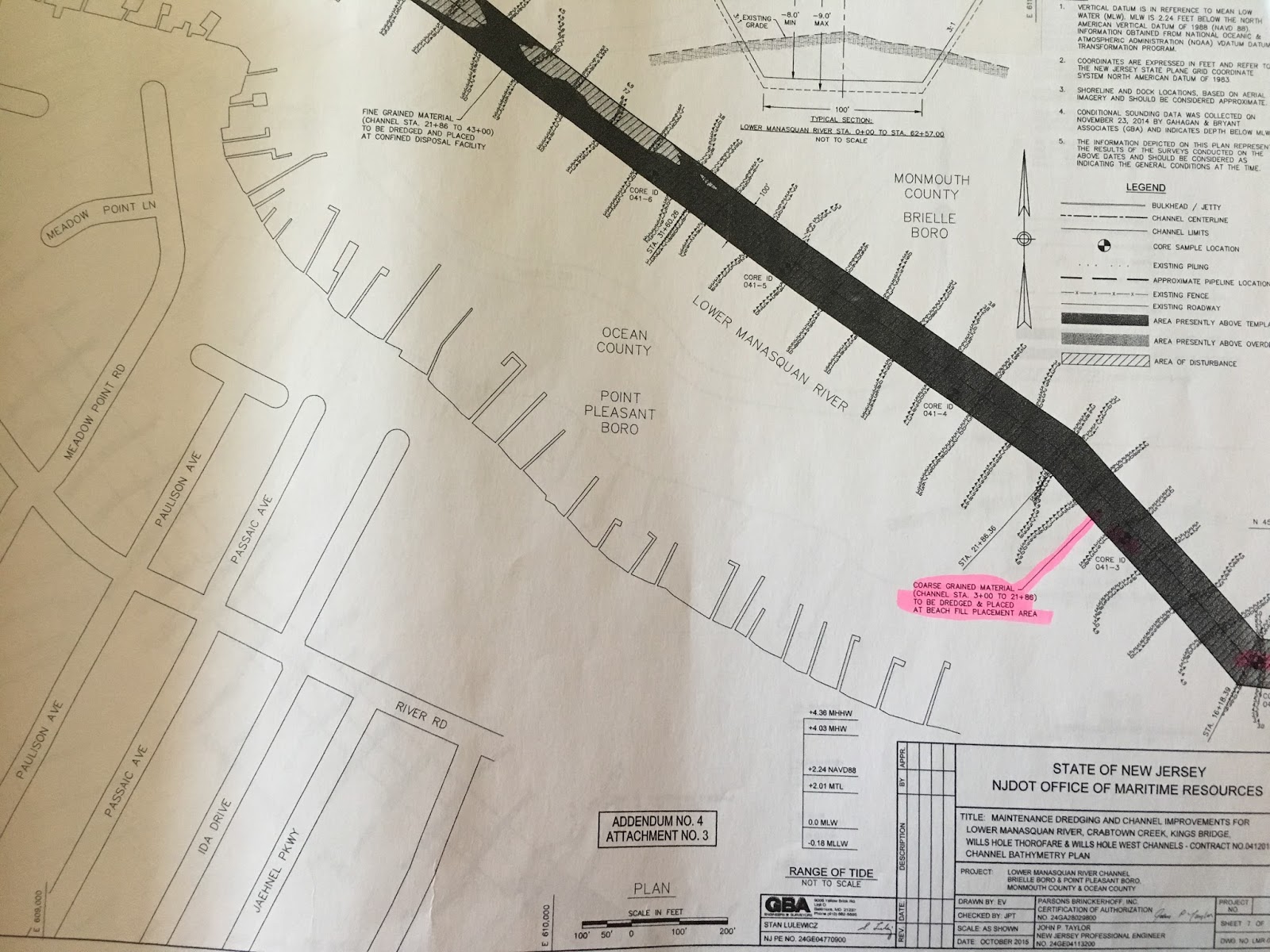
The Manasquan Inlet dredging project was permitted and put out to bid in the fall of 2015. The project permitted the dredging of the Lower Manasquan River Channel, Crabtown Creek Channel, Kings Bridge Channel, Wills Hole Thorofare, and Wills Hole West Channel. In total, over 100,000 cubic yards of material were permitted to be removed from these navigation channels.

In New Jersey, only material that is 75% sand or greater is allowed to be placed on beaches. The State however goes a step beyond this and only places material that is 90% or greater sand on bathing beaches (ie lifeguarded beaches), and 75% or greater sand material may be placed on non-bathing beaches (for example a bayside beach without a lifeguard). This is important for two reasons: 1) grain size directly relates to sand quality, which is an important consideration for those residents and visitors who come to the Jersey Shore to recreate on our world renowned sand beaches. 2) 90% sand or greater is given a “pass” from further chemical analysis because NJDEP have determined that once material reaches 90% sand in grain size, that material no longer is a risk for contamination. Therefore once this material is determined to be 90% or greater sand, no further chemical analysis is required. 

A sediment grain size analysis evaluating core samples taken at lengths along the channels was conducted by NJ Department of Transportation and reviewed by NJDEP and COA.

Roughly 57,000 cubic yards of sediment from the channels was found to be less than 90% sand - fine grained mud and silt. Gull Island is a CDF that sits smack in the middle of the river, and was designated and permitted as the receptacle for the majority of the fine grained material.

Caption: Gull Island CDF elevation map - a "bowl" for the fine grained dredge slurry (courtesy of Jersey Shore Drone)


However, approximately, 47,500 cubic yards of dredged material in specific locations of the Lower Manasquan Channel and Wills Hole Thorofare were found to contain 90% sand or greater, and  therefore suitable for placement on the beach between Manasquan Jetty and Brielle Road. This area of the beach was replenished by a larger federally overseen project in the past, however due to ocean currents and storms, is prone to erosion. Placing appropriate sand from the dredging project directly onto the beach helps to supplement and fortify the beach at this erosion prone area, and saves time, money and space for this dredging project, and future dredge and beach nourishment projects.

Caption: dredging Wills Hole Thoroughfare next to Gull Island CDF (photos courtesy of Jersey Shore Drone):

Sand that has been in the bays for several months, and even years, typically appear dark compared to sand that is found on the beach due to the presence of organic content from decaying vegetation and animals and the settling of these particles to the bay floor.  As this displaced sand dries and is exposed to sunlight and wave action, the dark organic material will weather and bleach out, and its color will change to resemble the color of sand that typically is found on New Jersey beaches.  This is similar to what we observe in typical beach replenishment projects in New Jersey: the sand that is pumped onto area beaches from the ocean and inlets is also dark when first placed on the beach, and then it lightens as it dries and is exposed to sunlight. The hydraulic dredging process may also pick up debris and trash that was buried in or sat on top of the sediment. 
Caption: 90% or greater sand with darker organic content that was pumped from Manasquan Channel and Wills Hole Thoroughfare directly onto the beach. Sunlight, rain, and wind action will eventually weather away  and wash out the darker organic matter leaving the lighter colored sand behind (photos courtesy of Jersey Shore Drone).

The site of a pipe on the beach releasing a dark colored slurry is an uncommon one for many people. However, when properly designed and vetted, these projects represent an innovative and beneficial use of material to protect properties and communities, save time and money, and perhaps contribute to less frequent large scale, federal beach nourishment projects that cost millions of dollars.

Caption: dredge slurry containing 90% or greater sand is pumped onto the Manasquan Beach, providing erosion control and protection from storms (photo courtesy Zach Lees):


It may not always be pretty -while there was some debris and trash picked up by the dredging process, the Borough of Manasquan worked in closely with NJDOT to utilize their beach rakes to remove this material, and with further coordination from the dredging contractor, ensured that larger items were captured prior to placement on the beach.


Caption: Borough of Manasquan raking the newly placed sand for any debris and shells that made it through the screens (photo courtesy Zach Lees).


Caption: Video taken by Jersey Shore Drones shows the Borough of Manasquan raking out any debris and spreading the newly placed sand out to weather out the darker organic material.


COA reviewed the permits and sediment analysis authorizing this project, and visited the beach placement site with NJ Department of Transportation (state agency in charge of state navigational channel dredging) and a representative from the Borough of Manasquan. The sediment analysis showed that each core sample was 90% or more sand, and that the dredged areas that were designated for beach placement were chosen with caution in mind, and a clear understanding of the value of New Jersey’s beautiful beaches. 


While the initial placement of this material may look a bit different than the surrounding sand, this is a temporary issue that will fade away with time, and this type of project is a model for the type of innovative beneficial use projects that can be designed to help move forward necessary navigational channel dredging, while also fortifying NJ’s beaches from storms and sea level rise.


NOTE: most all of the pictures we used of the Manasquan Channel dredging project, including the one below, are courtesy of Jersey Shore Drone, who has an incredible website that we highly recommend: http://www.jerseyshoredrone.com/2016/11/njdot-manasquan-river-dredging-11272016.html

Caption: a final shot by Jersey Shore Drone of the beach placement site. Note the "bump out" already provided by the project, in an area that was previously eroded.


[1] Credit to Jersey Shore Drone, who has done some incredible work visualizing and documenting many of these locations on the Jersey Shore. http://www.jerseyshoredrone.com/2016/04/nj-dot-manasquan-river-dredging-project.html

Thursday, January 28, 2016

Terrapins Saved for the Season


 The New Jersey Department of Environmental Protection (NJDEP) has immediately closed the commercial harvest season for the northern diamondback terrapins based on overharvesting concerns. The diamondback terrapin has not been listed as threatened or endangered in New Jersey; its status is listed as ‘decreasing’. Due to an increase in demand from out-of-state aquaculture operations and overseas food markets, terrapin harvesting has been on the rise.


The diamondback terrapin is the only species of turtle that lives in the brackish waters of New Jersey’s coastal marshes and estuaries. Past COA Board of Trustees member John Wnek and current Board member Jeff Martin have both worked on terrapin issues for years. They have dedicated their time to protecting, rescuing, and releasing the diamondback terrapin, as well as coordinating education programs about the turtle’s importance in the ecosystem. This harvesting closure is an important step in protecting the diamondback terrapin, ensuring the population remains healthy and thrives.

Wednesday, January 13, 2016

What’s Up with Water in New Jersey?

                People have a complex relationship with water. We swim in it and recreate on it, fish from it and withdraw huge amounts from rivers and coastal waters for industrial use and drinking water. At the same time, we discharge millions of gallons of wastewater right back into those waterways and waterbodies. Continued population and development pressures, coupled with the present and future impacts of climate change, threaten the quality and abundance of this most essential resource. Unfortunately, New Jersey has done a poor job in planning and regulating these issues. As a result, NJ is losing hard won progress and is actively backsliding on water quality protections.

This past year was one of the driest on record for New Jersey, with nearly one-fifth (located mostly in Central and Northeastern) of the state classified in a moderate drought and nearly 90 percent of the state listed as abnormally dry.[1] These low water levels stress ecosystems and drinking water supplies. This ‘trend’ extends back several years, and, with the ever more apparent effects of a warming climate, foreshadows a new normal. As our own NJDEP has stated, “[d]espite a trend toward more precipitation, the Northeast is seeing longer periods without rainfall and longer growing seasons. The result is a drier growing season, especially during the summer months, when temperatures and evapotranspiration are highest. This summer’s drying trend is exacerbated by reduced recharge from spring snowmelt. New Jersey has experienced one severe water-supply drought (2001-2002) and three minor ones (2005, 2006 and 2010) in the last decade.”[2] Even now, the NJDEP Drought Information website shows “a Drought Watch remains in place in the Northeast, Central, and Coastal North Water Supply Regions. . .  Substantial rainfall will be needed over the coming months to restore water supply reserves in preparation for the high-demand season that beings in May.”[3] Yet, NJDEP has neglected the critical tasks of inventorying and managing this precious resource, as the current Water Supply Master Plan (WSMP) is 20 years old and 15 years overdue, despite widespread protest and opposition from elected officials and environmental organizations.[4]

The WSMP inventories the amounts of surface and underground drinking water in the State and compares it to the amounts withdrawn for residents, business, power production, and farming in order to achieve a balance between development, water withdrawals, and environmental health. Overdevelopment and an expanding population creates more impervious surface, which inhibits rainwater from percolating into the ground to recharge aquifers and increases water withdrawals, putting our groundwater resources at risk.[5] Without a master plan in place, New Jersey could face severe water shortages into the future.

Furthermore, building in low lying areas, much of which acts as a buffer to absorb run off and storm surge, should be discouraged due to climate change impacts of sea level rise, extended dry periods (which dry out soil and decrease its ability to absorb rain) followed by heavy rain events, and increased frequency of storm events.[6] Yet, in the past year, New Jersey has amended two essential sets of regulations protecting critical coastal and riparian areas that buffer and protect communities from flood waters and absorb nutrients and pollutants before they reach waterbodies. NJDEP consolidated a patchwork of coastal development regulations and ‘streamlined’ it into what is known as the Coastal Zone Management Rules (CZMR). These changes enable even more development in vulnerable coastal areas through a myriad of measures, including easing the process for getting waterfront building permits and enabling larger upland development in the coastal zone.[7] The Flood Hazard Area Control Act (FHACA) establishes buffer distances for streams and rivers, and addresses how we develop in these riparian and coastal areas. These regulations have also been ‘streamlined, which in effect, removes protective waterway designations, and allows increased and unmonitored development in essential riparian, coastal, and wetland habitat.[8]

NJDEP is also in the process of ‘updating’ its Water Quality Management Planning regulations (WQMP).[9] These rules are required for New Jersey to meet its obligations under the Federal Clean Water Act, and determine, among other things, the cumulative water resource impacts of future development, how to manage and restore existing water quality impairments, and how NJ expects to maintain existing water quality.  However, simply put, NJDEP’s proposed updates to the WQMP are damaging to water quality protection, and allow for increased development and associated water quality impacts from sewers, wastewater treatment plants, and runoff in coastal areas.

Overall, New Jersey has a holistic and systemic problem. Development in coastal and riparian areas is continuing unabated, even as the public safety, economic, ecosystem, and water quality impacts of this type of development become clear (FHACA, and CZMR). New Jersey continues to use vast amounts of surface and ground water for drinking, industry, and agriculture, even while drought continues to impact our region (WSMP). New Jersey is also failing to safeguard the water quality gains made in the past, and is failing to properly plan for the future impacts of development on these gains (WQMP).

Stream and groundwater withdrawals, wastewater and industrial discharges, and development in coastal and riparian habitat are continuing unrestricted. Poor integration among these regulations and a lack of planning for future population increases and development will stress ecosystems, put human health at risk, and is a dangerous and unsustainable path into an uncertain climate future.

New Jersey’s water protection laws and planning are heading in the wrong direction. Clean water for drinking, swimming, fishing, and agriculture is invaluable.  Clean Ocean Action will continue to fight for clean water, and encourages the public to engage with us to protect this most basic and essential resource. Follow our social media for important updates and action alerts, call or email your elected officials and speak up for water quality and habitat protections, and align your lifestyle and consumption patterns with low impact and environmentally friendly values.


[2] Climate Change in New Jersey: Temperature, Precipitation, Extreme Events and Sea Level, NJDEP, available at http://www.nj.gov/dep/dsr/trends/pdfs/climate-change.pdf
[5] According to preliminary research by the Association of New Jersey Environmental Commissions (ANJEC), more water is being taken out than is being replenished in one of our major aquifers, the Kirkwood-Cohansey in South Jersey. That aquifer, which runs beneath southern Monmouth County and all of Ocean County, supplies drinking water to approximately 3 million of New Jersey’s 9 million residents. 

Monday, March 23, 2015

NJ Seismic Study is Back!

Despite opposition from New Jersey, federal, state, and local officials and thousands of citizens, NOAA Fisheries recently published a proposed Incidental Harassment Authorization in the Federal Register for the taking, harm or harassment, of marine mammals for the seismic survey offshore of New Jersey scheduled for June through August of 2015. This seismic study conducted by Columbia University’s Lamont-Doherty Earth Observatory and National Science Foundation along with University of Texas and Rutgers University lead researchers, was supposed to take place last summer, but due to public opposition and vessel issues, the study was delayed. The authorization allows over 32 marine mammal species, six of which are endangered, to be exposed to seismic air guns and three other acoustic blast technologies, all are known to be harmful to marine life. Clean Ocean Action has been working vigorously to stop this dangerous seismic study and we encourage you to join us in the fight.

Public comments on the Incidental Harassment Authorization can be submitted by April 16th. Instructions on how to send in your comments:

Mail Comments to:
Jolie Harrison
Supervisor, Incidental Take Program
Permits and Conservation Division,
Office of Protected Resources
National Marine Fisheries Service
1315 East-West Highway, Silver Spring, MD 20910.

Email Comments to:
ITP.Cody@noaa.gov.
Please include 0648-XD773 in the subject line.

Monday, December 9, 2013

What's Next, One Year After Sandy

Waves of Action Program Culminates with Distinguished Speakers,
Panel Discussions, and Sea Level Rise Survey Results

Full house at McLoone's Pier House in Long Branch
On Saturday, Clean Ocean Action (COA) held a conference with concerned citizens more than one year after Superstorm Sandy at McLoone’s Pier House in Long Branch, New Jersey.

A celebration of the culmination of Waves of Action “For The Shore,” the year-long Sandy response program, the conference highlighted the extraordinary success of Waves of Action volunteers and project leaders, released results of a summer-long survey on sea level rise and accountability, and included panel discussions with distinguished speakers.  Panelists and speakers discussed, ‘What Do Communities Need Now and How Can Volunteers Help?’ and ‘What Resources are Available for Resiliency and Environmental Stewardship?’

One hundred and seventy three citizens were surveyed during the Clean Ocean Action Shore Tips (C.O.A.S.T.) campaign this past summer to garner public opinion about sea level rise and climate change, the impacts from Superstorm Sandy and what citizens believe elected officials and the general public should do in response to sea level rise and climate change.  The results are clear; the majority of the public believe that sea level rise exists and that a broad array of both citizen action and government action are needed to reduce the impacts.  Sea level rise survey and report by Macailagh McCue, 2013 C.O.A.S.T. Intern, 2014 Masters Candidate, James Madison University.

“Over the course of the past summer, COA’s sea level rise survey of the people of the Jersey Shore led to one inescapable conclusion – nearly everyone agrees the climate is changing, the sea is rising and that it’s up to us to make changes in our lives, communities and laws,” said Clean Ocean Action Coastal Policy Attorney Sean Dixon.

“New Jersey Recovery Fund grantees have been doing amazing work throughout the state of NJ to promote a recovery process that is transparent, sustainable, creative and equitable. They are currently serving as watchdogs, healers, educators and leaders to better prepare NJ for future disasters. I look forward to sharing more information about their work with conference participants,” stated Emilio DeLia, New Jersey Recovery Fund Project Manager.

“As the founder and editor of Jersey Shore Hurricane News, I not only report the daily news, but I'm also at the helm of a community of people primarily in Ocean and Monmouth counties. The platform is a community resource and has been intimately involved in the post-Sandy recovery. Accordingly, with the long-term recovery still in its early stages, our communities will continually require a strong communications coalition,” explained Founder of Jersey Shore Hurricane News Justin Auciello.

“Nature is tremendously resilient if given the chance and volunteers can make a big impact,” stated Save Barnegat Bay Executive Director Britta Wenzel.

“The challenge for homeowners that want to rebuild in a more sustainable manner is a lack of resources to support that decision. Many residents are struggling just to rebuild what they had, and often the additive cost of building a more resilient home is prohibitive. Government programs and flood insurance payments should provide additional resources to assist homeowners and businesses build a more sustainable shore community,” said Sea Bright Volunteer Coordinator Frank Lawrence.

"The need was unprecedented, as was the response. But we may just be looking at the tip of an iceberg in future years, an iceberg quickly melting into higher sea levels as it rushes our way," stated NJ Reporter for NBC New York Brian Thompson.

“As time goes on, Superstorm Sandy won’t be given as much media attention, which is why it is important that groups like Clean Ocean Action continue to advocate for what needs to be done in the future.  It is important to restore the shore, but it is most important to think long-term and prevent future damage,” explained US Representative Frank Pallone, New Jersey, 6th District.

"Clean Ocean Action's comprehensive response to Hurricane Sandy, sea level rise, and extreme weather is impressive.  COA has been front and center engaging shore lovers at the grassroots, businesses, and elected officials to be proactive about our resiliency in the midst of climate change," said Lauren Townsend, NJ Director of US Strong. “Congratulations to COA's board, staff, and activists for accomplishing so much throughout 2013's Waves of Action, and thank you for your counsel and partnership advocating for national action, and the creation of a federal extreme weather relief and protection fund," added Townsend.

Waves of Action ‘For the Shore’ was Clean Ocean Action coalition’s response to Superstorm Sandy. It has been a remarkable year of challenges and achievements, and there are thousands of stories of tenacity, compassion, resiliency and hope.  We believe the program must now evolve to help move toward restoration—minding the rules of Mother Nature and encouraging environmental stewardship.  Indeed, it’s not really a choice, it’s a mandate,” said Clean Ocean Action Executive Director Cindy Zipf.

Through Waves of Action “For The Shore,” almost 14,000 volunteers have helped to improve and protect the marine environment through 281 projects, with more than 125 different organizations, in over 70 towns in New York and New Jersey.  For more information, visit www.ForTheShore.org.

The Waves of Action Conference was sponsored by Whole Earth Center of Princeton, Montecalvo Recovery Facility, New Jersey 101.5 FM Radio, Barefoot Wine and Bubbly.


The Waves of Action program was sponsored by Aveda, Bloomberg, Dave Matthews Band, Provident Bank Foundation, LUSH Cosmetics, Rebuild Recover, Mickey Hart Band, Geraldine R. Dodge Foundation, All-State Foundation, Spinach for Rip & Joe Schiavone Foundation, Eileen Fisher, Inc., The Harriet Greenfield Foundation.