Showing posts with label NJDOT. Show all posts

Thursday, February 2, 2017

Dredging and Beneficial Use - Part 2: Shark River Dredging Project

Introduction
For over 30 years, Clean Ocean Action has worked to review, develop, and advocate for community driven dredged material management solutions. By viewing dredged material as a resource, and emphasizing community input and engagement, COA has reviewed and identified potential beneficial use options for dredged material placement in many different contexts and uses. Above all, throughout this process, COA has advocated for environmental protection, and community involvement and support as key tenets of our position. As we say here at Clean Ocean Action, “we know mud”.
This is part two of our series on the beneficial use of dredged material.
SHARK RIVER - Critical Navigation, Innovative Dewatering, and Beneficial Use


The Shark River is a tidal estuary bordered by five towns - Neptune Township, Neptune City, Avon, Belmar and Wall Township. The river is popular for stand up and kayak paddling and bird watching, as well as safe harbor for hundreds of commercial and recreational fishing and pleasure boats. The marinas surrounding the river have also become a focus of redevelopment with bars and restaurants flanking these marina hubs. For over two decades, critical dredging of channels was needed to allow the passage of vessels into and out of the estuary. However, no satisfactory location was available to place the estimated 102,000 cubic yards of dredged material. In fact, the old CDF for Shark River is actually the site of the Seaview at Shark River Island condominium community; a clear example of the lack of open space in the area. Everyone agreed that the river needed to be dredged, but there was no consensus as to where the material could be placed, or even dewatered for transport. An innovative solution was necessary to get this project off the ground.

Enter a dedicated coalition of State, County and local leaders that effectively advocated for the project, including Senator Jen Beck, Committeeman Randy Bishop, County of Monmouth, Board of Chosen Freeholders, New Jersey Department of Transportation (NJ DOT) Office of Maritime Resources, New Jersey Department of Environmental Protection (NJ DEP), and the governing bodies of the participating municipalities including Neptune City, Neptune, Belmar, and Wall. Recognition must also go to the Shark River Cleanup Coalition, who has been advocating for the dredging of the Shark River for many years now. 

NJDOT put a concept and "workable plan" out to bid. Mobile Dredging and Pumping Co., out of Chester, PA. Mobile Dredging was awarded the $7.6 million contract in the summer of 2015, as the responsible low cost bidder for the project, and with coordination from NJDOT and NJDEP, a workable solution was created that used innovative technology to dewater the dredged material slurry on a very small footprint surrounded by homes, businesses, and marinas, before trucking it to the Monmouth County Reclamation Center for use as landfill cover. The project removed approximately 102,000 cubic yards of sediment from the River comprised of sand and silt using hydraulic dredging, and then piped the slurry via a secure welded pipeline to the selected dewatering location.

Caption: far off in the Shark River, the hydraulic dredge removes sediment to improve navigation (photo courtesy of Cindy Zipf).
The dredging had started late last fall and was halted on January 1, 2016, due to state regulations in place to protect spawning and the early life stages of winter flounder and anadromous fish. During this initial phase of the project, “geotubes” were used to dewater the slurry before trucking the material off to be used. Geotubes are large fabric bags that the slurry is pumped into, with pressure forcing the water out of the bag while the sediment remains.
Caption: this image shows the piping system that moves the dredge slurry to the dewatering site, as well as the pipe that takes the water that has been removed out of the sediment and returns it back to the river (photo courtesy of Cindy Zipf).

Caption:  dredge slurry is pumped into the geotube. The fabric is designed to let water escape, leaving behind the sediment for removal and use as cover at a landfill.


When the project was restarted in July, the dewatering process was changed to handle larger amounts of material and get the project done before the dredge window closed.

Caption: a first look at the dewatering site. (video courtesy of Cindy Zipf).


This dewatering process is called “mechanical dewatering” and utilizes transportable and modular centrifuges and belt presses to separate usable sand out of the finer sediment, then mechanically squeeze the water out of the slurry. The process is rather impressive to behold, and when up and running, is able to process a huge amount of material on a very small footprint – perfect for the heavily built up mid-Atlantic coastline.
Let’s walk through the process:


First, a hydraulic dredge removed sediment in a slurry that is piped to the dewatering location. This pipe runs to a large tank that slows down the flow of water and allows larger pieces of debris to settle out.

Caption: Rick, from Clean Ocean Action, talks to the contractor supervisor in front of one of the large tanks where the dredge slurry is first pumped to (photo courtesy of Cindy Zipf).
The slurry is then pumped into several centrifuge and screen type machines, that are able to sort out debris and coarse sand sediments from the muds and silts. These machines are also able to remove large amounts of debris and trash from the sediment as well. The idea is that the larger pieces of debris and sand can actually harm the belt presses which squeeze the water out, so removing them on the front end of this process saves those machines, and also allows for use of sand! This project produced about 500 cubic yards of sand that was trucked and placed on the Township of Neptune’s beaches.

Caption: Bill from NJDOT shows us the centrifuge systems which remove the larger sediments and debris on the front end of this process (photo courtesy of Cindy Zipf).


Caption: The centrifuges are able to remove debris and shell fragments which are removed from river and properly disposed of (photos courtesy of Cindy Zipf).


 Caption: Zach from COA inspects the sand removed off of the front end this process - over 90% sand = perfect for beach placement (photo courtesy of Cindy Zipf).

The slurry then travels to belt presses which wring the water out of the slurry and extrude a dredge material “brownie” (photo courtesy of Cindy Zipf)..
Caption:  the mechanical dewatering process in a series of videos (courtesy of Cindy Zipf).

1. After having larger sediment and debris removed, a polymer is added to the slurry and then spread out onto the fabric conveyor belts

2. The conveyor belts transport the slurry through a series of belt presses, which mechanically squeeze the water out of the material. This process occurs several times. Water from this process is treated and sent back into the Shark River.


3. The dredge material, now dewatered, is extruded out of the belt presses.


Caption: the result of this dewatering process is a sediment "brownie" that has been wrung dry, and easily transportable (photo courtesy of Cindy Zipf).


This material is then scooped up and put in a holding area, where dump trucks then take it to the Monmouth County Reclamation center, where it will be mixed with sand and used as landfill cover (photo courtesy of Cindy Zipf).
The Shark River project is a great example of coupling an innovative dewatering process with beneficial use of the material, in order to meet the constrains of the project. The mechanical dewatering process took up about an acre of area, was self contained and rather unobtrusive to the surrounding area, and allowed sand to be harvested off the front end for beach placement, and sediment off the back end for landfill cover (photo courtesy of Cindy Zipf).

A final note: the footprint of one acre for dewatering was barely enough room to get this job done. A larger footprint for dewatering would have made the project less expensive and faster to complete. Furthermore, Monmouth County Landfill accepting the material for free was a key in making this project feasible. This all goes to show that finding large scale, affordable, beneficial use opportunities is really challenging - and cooperation and coordination between all entities is absolutely essential to the success of these types of projects.


Thursday, January 26, 2017

Dredging and Beneficial Use - Part 1: Manasquan Inlet


1

Introduction
For over 30 years, Clean Ocean Action has worked to review, develop, and advocate for community driven dredged material management solutions. By viewing dredged material as a resource, and emphasizing community input and engagement, COA has reviewed and identified potential beneficial use options for dredged material placement in many different contexts and uses. Above all, throughout this process, COA has advocated for environmental protection, and community involvement and support as key tenets of our position. As we say here at Clean Ocean Action, “we know mud”.

In the last several years, we have been monitoring what many call a “dredge crisis” – thousands of cubic yards of dredge material are waiting to be dredged out of critical navigational channels, however, without proper planning and community engagement, and the use of innovative technologies, the disposal options for all of this dredged material is limited. Without a plan to deal with all of this dredged material, these projects are put on hold; in some cases, for decades.

Traditionally, Confined Disposal Facilities (CDFs) were used as both temporary and final disposal locations for this material. CDFs are engineered structures designed to provide storage for the soupy mix of suspended solids that are dredged out of channels and pumped into them. These structures traditionally appear as the familiar hills and berms that you may see rising out of the wetlands in many locations. In general, these CDFs can fill up rather quickly, are expensive to continually maintain, and many of these CDFs have fallen into disrepair over the years, further limiting disposal options.

Today, there are many solutions for clean dredge material placement including beneficial use options such as using the sediment in construction fill or cover for landfills (for contaminated dredge material the options are rightfully more limited). However, for these uses, the soupy, watery dredged material must be “dewatered” so that it can be transportable and useful. Most dewatering methods involve the use of a CDF, the construction of temporary CDFs on land to dewater the material before trucking it off, or even the use of other technologies to dewater the material in short amounts of time and on increasingly smaller footprints.

Furthermore, there are methods that can beneficially use dredged material without dewatering. Methods have been continually perfected to perform habitat restoration projects through the creation of “living shorelines” and the “thin layer placement” of material on a drowning marsh, and for the right types of material, can be pumped onto bayside and ocean beaches to fortify erosion areas and safeguard communities from storms.

COA recently visited two separate locations where innovative dewatering and placement methods have resulted in projects that provide benefits to boaters on the water, communities on land, and beneficial material for a multitude of uses.

Manasquan Inlet – Channel Dredging, Beach Placement and Erosion Control


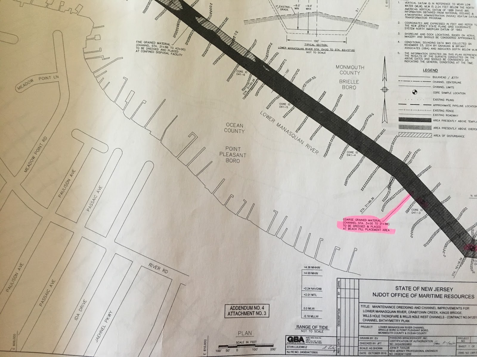
The Manasquan Inlet dredging project was permitted and put out to bid in the fall of 2015. The project permitted the dredging of the Lower Manasquan River Channel, Crabtown Creek Channel, Kings Bridge Channel, Wills Hole Thorofare, and Wills Hole West Channel. In total, over 100,000 cubic yards of material were permitted to be removed from these navigation channels.

In New Jersey, only material that is 75% sand or greater is allowed to be placed on beaches. The State however goes a step beyond this and only places material that is 90% or greater sand on bathing beaches (ie lifeguarded beaches), and 75% or greater sand material may be placed on non-bathing beaches (for example a bayside beach without a lifeguard). This is important for two reasons: 1) grain size directly relates to sand quality, which is an important consideration for those residents and visitors who come to the Jersey Shore to recreate on our world renowned sand beaches. 2) 90% sand or greater is given a “pass” from further chemical analysis because NJDEP have determined that once material reaches 90% sand in grain size, that material no longer is a risk for contamination. Therefore once this material is determined to be 90% or greater sand, no further chemical analysis is required. 

A sediment grain size analysis evaluating core samples taken at lengths along the channels was conducted by NJ Department of Transportation and reviewed by NJDEP and COA.

Roughly 57,000 cubic yards of sediment from the channels was found to be less than 90% sand - fine grained mud and silt. Gull Island is a CDF that sits smack in the middle of the river, and was designated and permitted as the receptacle for the majority of the fine grained material.

Caption: Gull Island CDF elevation map - a "bowl" for the fine grained dredge slurry (courtesy of Jersey Shore Drone)


However, approximately, 47,500 cubic yards of dredged material in specific locations of the Lower Manasquan Channel and Wills Hole Thorofare were found to contain 90% sand or greater, and  therefore suitable for placement on the beach between Manasquan Jetty and Brielle Road. This area of the beach was replenished by a larger federally overseen project in the past, however due to ocean currents and storms, is prone to erosion. Placing appropriate sand from the dredging project directly onto the beach helps to supplement and fortify the beach at this erosion prone area, and saves time, money and space for this dredging project, and future dredge and beach nourishment projects.

Caption: dredging Wills Hole Thoroughfare next to Gull Island CDF (photos courtesy of Jersey Shore Drone):

Sand that has been in the bays for several months, and even years, typically appear dark compared to sand that is found on the beach due to the presence of organic content from decaying vegetation and animals and the settling of these particles to the bay floor.  As this displaced sand dries and is exposed to sunlight and wave action, the dark organic material will weather and bleach out, and its color will change to resemble the color of sand that typically is found on New Jersey beaches.  This is similar to what we observe in typical beach replenishment projects in New Jersey: the sand that is pumped onto area beaches from the ocean and inlets is also dark when first placed on the beach, and then it lightens as it dries and is exposed to sunlight. The hydraulic dredging process may also pick up debris and trash that was buried in or sat on top of the sediment. 
Caption: 90% or greater sand with darker organic content that was pumped from Manasquan Channel and Wills Hole Thoroughfare directly onto the beach. Sunlight, rain, and wind action will eventually weather away  and wash out the darker organic matter leaving the lighter colored sand behind (photos courtesy of Jersey Shore Drone).

The site of a pipe on the beach releasing a dark colored slurry is an uncommon one for many people. However, when properly designed and vetted, these projects represent an innovative and beneficial use of material to protect properties and communities, save time and money, and perhaps contribute to less frequent large scale, federal beach nourishment projects that cost millions of dollars.

Caption: dredge slurry containing 90% or greater sand is pumped onto the Manasquan Beach, providing erosion control and protection from storms (photo courtesy Zach Lees):


It may not always be pretty -while there was some debris and trash picked up by the dredging process, the Borough of Manasquan worked in closely with NJDOT to utilize their beach rakes to remove this material, and with further coordination from the dredging contractor, ensured that larger items were captured prior to placement on the beach.


Caption: Borough of Manasquan raking the newly placed sand for any debris and shells that made it through the screens (photo courtesy Zach Lees).


Caption: Video taken by Jersey Shore Drones shows the Borough of Manasquan raking out any debris and spreading the newly placed sand out to weather out the darker organic material.


COA reviewed the permits and sediment analysis authorizing this project, and visited the beach placement site with NJ Department of Transportation (state agency in charge of state navigational channel dredging) and a representative from the Borough of Manasquan. The sediment analysis showed that each core sample was 90% or more sand, and that the dredged areas that were designated for beach placement were chosen with caution in mind, and a clear understanding of the value of New Jersey’s beautiful beaches. 


While the initial placement of this material may look a bit different than the surrounding sand, this is a temporary issue that will fade away with time, and this type of project is a model for the type of innovative beneficial use projects that can be designed to help move forward necessary navigational channel dredging, while also fortifying NJ’s beaches from storms and sea level rise.


NOTE: most all of the pictures we used of the Manasquan Channel dredging project, including the one below, are courtesy of Jersey Shore Drone, who has an incredible website that we highly recommend: http://www.jerseyshoredrone.com/2016/11/njdot-manasquan-river-dredging-11272016.html

Caption: a final shot by Jersey Shore Drone of the beach placement site. Note the "bump out" already provided by the project, in an area that was previously eroded.


[1] Credit to Jersey Shore Drone, who has done some incredible work visualizing and documenting many of these locations on the Jersey Shore. http://www.jerseyshoredrone.com/2016/04/nj-dot-manasquan-river-dredging-project.html

Wednesday, June 19, 2013

New Jersey Boating Season Now Open!

The 2013 boating season is open! Jersey Shore waters are now open for recreation and tourism. The state is continuing to remove debris from our waterways.  Since early March, state-hired contractors have been removing floating and submerged debris from Bergen to Cape May Counties as well as in Delaware Bay.  These contractors are helping clean up our waters seven days a week. Additionally, NJDOT is aerially marking locations needing cleanup and ensuring the safety of state channels. Despite cleanup efforts, please use caution when traveling through our waterways for shifting debris and shallow shoals. Boaters should call 1-877-WARN DEP if they observe debris or shoaling while traveling on state waters.  Boaters can access Local Notices to Mariners (LNMs) for New Jersey here. For more information on NJ’s debris cleanup, click here.


Boat sewage can be a source of nonpoint pollution, degrading the water quality of our shores. Boat sewage can not only cause algae blooms, fish kills, and degradation of shellfish beds, but can also be harmful to human health. Many coastal areas have been designated as No Discharge Zones, preventing the dumping of treated and untreated sewage, and it is illegal to dump untreated sewage within 3 miles of any shoreline. In order to help protect our water quality, please use pumpout facilities. Unfortunately, as of the first of June, half of our pumpout facilities were closed due to Superstorm Sandy damage and repairs are underway. To see which pumpout facilities are open, please go here. Whether pumpout facilities charge or not for their services depends on the facility.


NY/NJ Baykeeper's Bayshore Pumpout Boat, the Head Mistress

Free pumpouts are provided:
  • In Jamaica Bay and the northern Bayshore region, NY/NJ Baykeeper runs two boats twice a week. For more information please call the Baykeeper office at 732-888-9870 ext 1 or click here.

  • In the Barnegat Bay region, Ocean County also provides 4 free pumpout facilities. The pump out boats typically operate through September. The boats are in service Friday- Monday from 10:00am to 6:00pm and can be contacted on the Marine VHF Radio Channel 9 by identifying the boat, its location, and service requested. Contact the following pumpout boats:
    • Circle of Life/ Water Warrior, Borough of Seaside Park, 732-793-3700
    • Waste Watcher/ Bay Sweeper, Tuckerton Seaport, 609-296-8868
    • Bay Saver, Brick Township, 732-262-1085
          For more information on Ocean County's Pumpout Boat Program, please go here.

    Click here for a useful boaters guide from NJSeagrant.

    Please help your waterway. If you observe any unusual conditions such as large numbers of floating dead fish, oil or chemical spills, or any waste being dumped in coastal waters, contact the appropriate agency immediately. See here for who to contact and let us know at
    COA, 732-872-0111.
    
    For more information about pumpout locations and to contact someone about a closed pumpout please call:

    Michael Danko, Sea Grant Consortium
    732-872-1300

    NJ Marine Trades Association
    732-292-1051